Excerpt taken from the Liphook Community Magazine
A Map of Old Liphook by Alan Wilson & Joan Finney
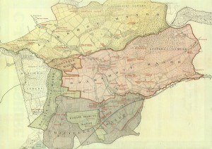
In conjunction with our series on the Origin and Growth of Liphook we thought it was appropriate to present a map of the Parish of Bramshott and Liphook, which, today we often call Liphook. The map we show is taken from Canon Capes ‘A Rural Hampshire Parish’ which was published in 1901.
The map shows that the present Parish subsumes the three ancient manors of Bramshott, Chiltlee and Ludshott in their entirety, Woolmer Forest and outlying parts of two other manors. Ludshott Manor is the north, Chiltlee Manor in the south and Bramshott Manor is sandwiched in between. Embedded in these three manors are outlying parts of Bohunt-Rogate Manor (an off spring of Harting Manor) and Oakhanger Manor.
A few points may be noted. Bramshott village is the only village that takes its name from a Manor. The village in Chiltlee Manor is, of course, Liphook itself and, with its railway station, the centre of gravity of the Parish, while Ludshott Manor has only the hamlet of Passfield. Conford lies on the boundary between Ludshott Manor and Oakhanger Manor, while Griggs Green is in Rogate-Bohunt Manor.
The road Liphook – Radford – Cold Ash – Seven Thorns – is labelled ‘Road to London’. There is another road marked the ‘London Old road by Haslemere’ which runs along Midhurst Road then turning down Highfields Road. We have been told that there is yet another road to London from Bramshott, along Rectory Lane and heading for Seven Thorns. Seven Thorns was a historic inn renamed the Spaniard in the 1960s ; however, following a fire the build has remained derelict for many years. As far as one can ascertain there are no references for it being used for coaching. The use of the direct road to Liphook by coaches ensured that the fortunes of Liphook would wax and those of Bramshott wane.

